Table of contents
What is a Flood?
Definition: Floods are an excessive overflow of water that submerges land which is usually dry.
They are caused by the volume of water within a body of water, such as a river or lake, exceeding its capacity and overflowing its banks due to factors such as heavy rainfall, rapid snowmelt, or obstruction of the water flow.
In simple terms, a flood is any overflow of water onto land that is normally dry.
Major causes of floods include
- Heavy Rainfall: The most common cause, leading to an excess of surface water.
- Snowmelt: Sudden warm temperatures can melt snowpacks, leading to runoff that rivers cannot accommodate.
- Overflow of Water Bodies: Lakes, rivers, and reservoirs can overflow their boundaries.
- Blocked Waterways: Debris, ice, or other obstructions can cause water to pool and eventually spill over.
- Human Factors: Poor land management, inadequate drainage, and urbanization can exacerbate flood conditions.
Types of Floods
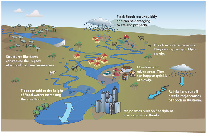
Flash Floods
- Floods occurring within six hours, mainly due to heavy rainfall associated with towering cumulus clouds, thunderstorms, tropical cyclones or during passage of cold weather fronts, or by dam failure or other river obstruction.
- This type of flood requires a rapid localised warning system.
- Flash floods occur due to high rate of water flow as also due to poor permeability of the soil.
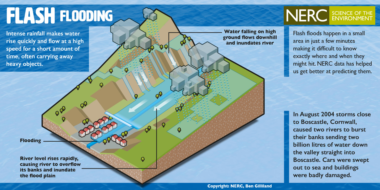
- Areas with hardpan just below the surface of the soil are more prone to floods as water fails to seep down to the deeper layers.
- The construction of buildings, highways, driveways, and parking lots increases runoff by reducing the amount of rain absorbed by the ground.
- This runoff increases the flash flood potential. During heavy rain, the storm drains can become overwhelmed or plugged by debris and flood the roads and buildings nearby.
- Low spots, such as underpasses, underground parking garages, basements, and low water crossings can become death traps.
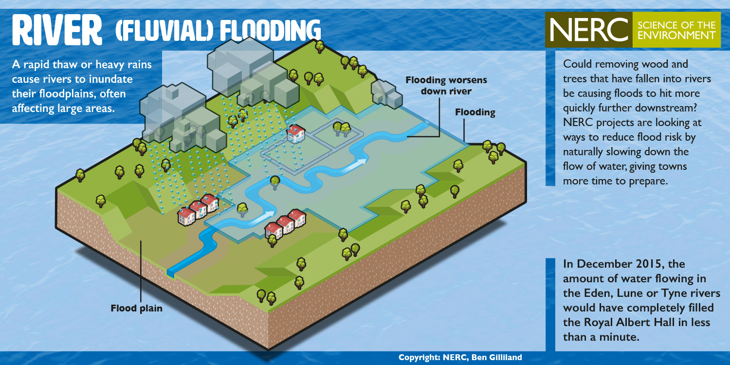
River Floods
- Floods caused by precipitation over a large catchment’s area, melting of snow or both. Built up slowly or on a regular basis, these floods may continue for days or weeks.
- The major factors of these floods are moisture, vegetation cover, depth of snow, size of the catchment’s basin, etc.
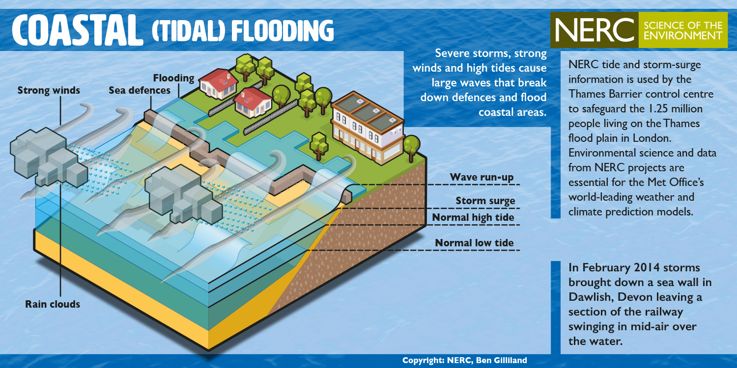
Coastal Floods
- Floods associated with cyclonic activities like hurricanes, tropical cyclones, etc generating a catastrophic flood from rainwater which often aggravate wind-induced storm and water surges along the coast.
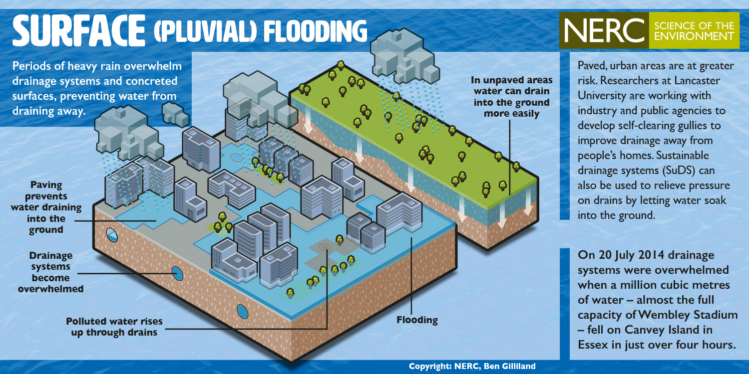
Pluvial Floods
- Occur when heavy rainfall creates a flood independent of an overflowing water body.
- Common in flat areas where water collects and does not drain quickly.
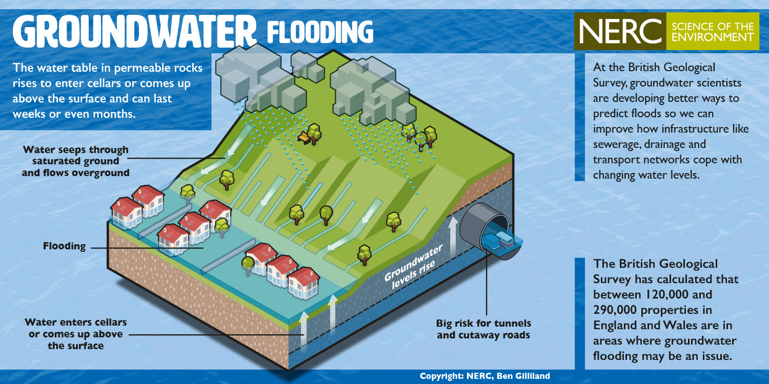
Groundwater Flooding
- It occurs when the water table rises to a point that water emerges on the ground surface, saturating the soil and flooding the area.
- This type of flooding is typically not linked directly to heavy rainfall or overflow from rivers. Instead, it can occur due to a gradual buildup of water underground which slowly seeps to the surface.
Urban Flood
- As land is converted from agricultural fields or woodlands to roads and parking lots, it loses its ability to absorb rainfall.
- Urbanisation decreases the ability to absorb water two to six times over what would occur on natural terrain.
- During periods of urban flooding, streets can become swift moving rivers, while basements can become death traps as they fill with water.

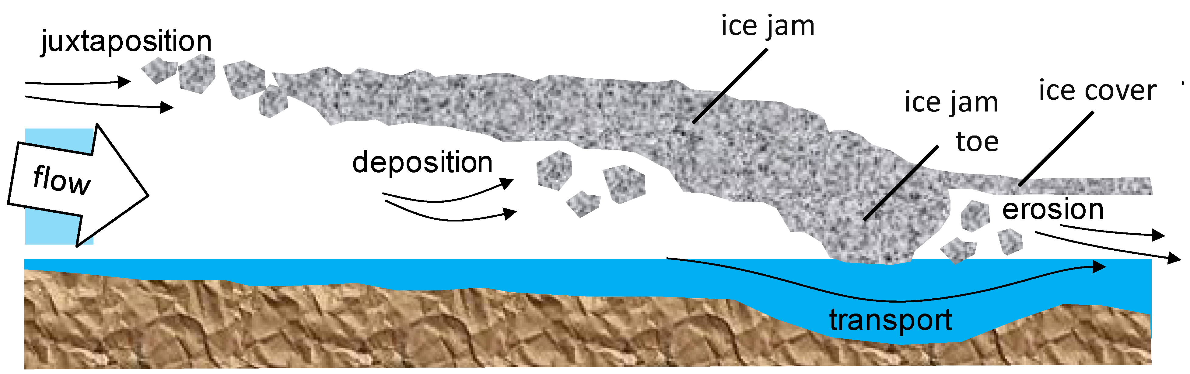
Ice Jam
- An ice jam is a phenomenon that occurs in rivers in cold climates. Chunks of ice accumulate at a particular point and obstruct the flow of water.
- This blockage can lead to sudden and severe flooding upstream as the river's natural course is impeded, while downstream areas may experience reduced water flow until the jam breaks.
Glacial Lake Outbursts Flood (GLOF)
- Many of the big glaciers which have melted rapidly and gave birth to the origin of a large number of glacier lakes.
- Due to the faster rate of ice and snow melting, possibly caused by global warming, the accumulation of water in these lakes has been increasing rapidly resulting in sudden discharge of large volumes of water and debris and causing flooding in the downstream.


Impacts of Floods
- Economic: Damage to infrastructure, agriculture, homes, and businesses leads to significant economic losses.
- Social: Loss of lives, displacement of communities, and long-term psychological impacts on affected populations.
- Environmental: Erosion, loss of wildlife habitats, and pollution of water bodies are common environmental impacts.
Management and Mitigation
- Forecasting and Early Warning Systems: Using meteorological data to predict flood events and alert at-risk populations.
- Infrastructure: Building flood defences like levees, dams, and floodwalls.
- Urban Planning: Implementing zoning laws, creating green belts, and enhancing drainage systems to manage runoff.
- Community Preparedness: Educating the public on flood risks and response strategies.
The Delta Works Project
The Netherlands, much of which lies below sea level, has developed one of the most sophisticated flood defense systems in the world, known as the Delta Works. This series of construction projects includes dams, sluices, locks, dikes, levees, and storm surge barriers.
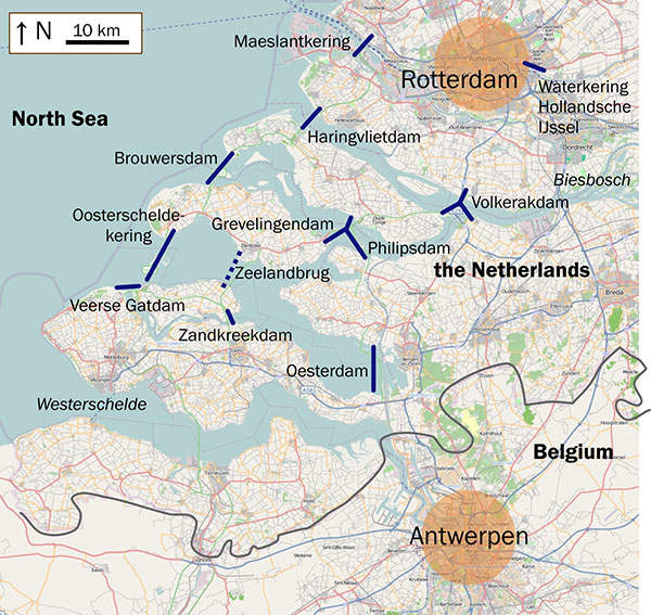
Key Components
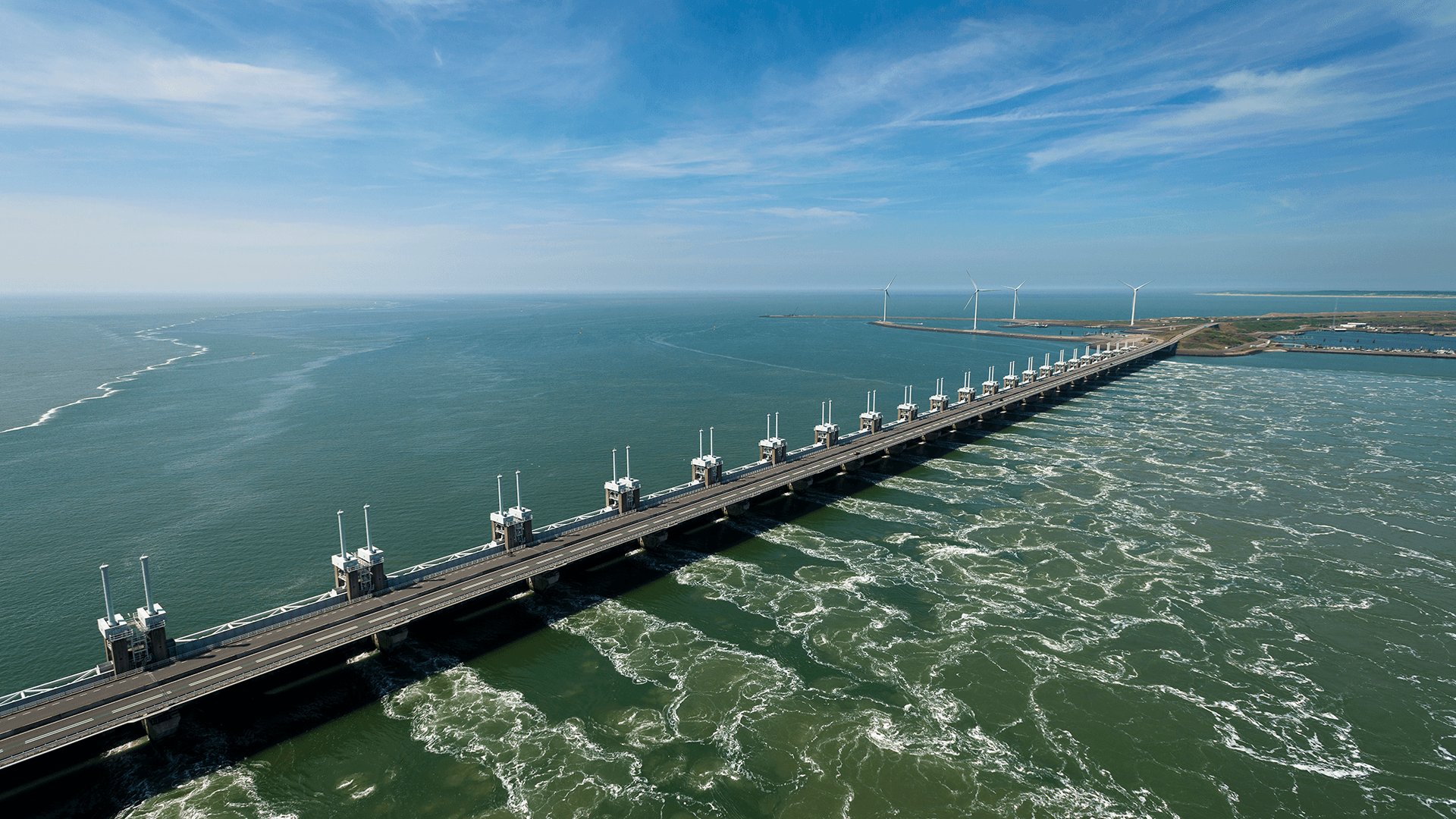
- Oosterschelde Barrier: Perhaps the most famous part of the Delta Works, this storm surge barrier has enormous sliding gates that normally remain open to allow for free passage of water and marine life. However, during high tide and storms, the gates can be closed, preventing sea surges from causing floods.
- Maeslantkering: Another notable component, this movable barrier protects Rotterdam, one of the busiest ports in the world. It consists of two massive arms that can close off the river mouth when a storm surge is predicted.
Impact
- Flood Prevention: By controlling sea and river water levels, these barriers significantly reduce the risk of flooding from storm surges, particularly in low-lying areas.
- Economic Security: Protecting the economic powerhouse of Rotterdam and its surrounding areas from flooding is crucial for maintaining the economic stability of the Netherlands and Europe.
- Environmental Considerations: The adjustable nature of the barriers allows for a balance between flood defense and maintaining environmental quality and marine biodiversity.
Community Involvement and Preparedness
In addition to large-scale infrastructural projects, the Netherlands also focuses on community-level flood preparedness:
- Flood Education: Dutch citizens are educated from a young age about the risks of living below sea level and the measures in place to protect them.
- Evacuation Plans: Detailed evacuation plans are regularly updated and practiced, ensuring that in the event of a flooding emergency, residents know exactly how to respond.
- Spatial Planning: Urban planning in the Netherlands often includes water-resilient infrastructure, such as water plazas that store excess rainwater and green roofs that reduce runoff.
Lessons for Other Regions
The approach taken by the Netherlands exemplifies how combining advanced engineering, environmental management, and community engagement can effectively mitigate the risk of floods. Countries and regions prone to flooding can adapt these strategies based on their specific geographical, climatic, and social contexts to improve their own flood management systems.
Understanding these aspects can help UPSC aspirants not only in geography but also in environment and disaster management topics, providing a comprehensive view of the risks and management strategies associated with floods.
Previous Post